HLMS
Da Ufopedia.
(Differenze fra le revisioni)
(Creata pagina con 'The '''High Latitude Monitoring Station''' ('''HLMS''') is located on the outskirts of Elmendorf Air Force Base near Anchorage, Alaska. HLMS was established in 1950 by the Depart...') |
(→Collegamenti esterni) |
||
| (17 revisioni intermedie non mostrate.) | |||
| Riga 1: | Riga 1: | ||
| + | {{Tradurre}} | ||
The '''High Latitude Monitoring Station''' ('''HLMS''') is located on the outskirts of Elmendorf Air Force Base near Anchorage, Alaska. HLMS was established in 1950 by the Department of Commerce; today, it is operated by the Geophysical Institute, with one technician on the site. HLMS instruments are connected to the Geophysical Institute by leased data lines. | The '''High Latitude Monitoring Station''' ('''HLMS''') is located on the outskirts of Elmendorf Air Force Base near Anchorage, Alaska. HLMS was established in 1950 by the Department of Commerce; today, it is operated by the Geophysical Institute, with one technician on the site. HLMS instruments are connected to the Geophysical Institute by leased data lines. | ||
| Riga 8: | Riga 9: | ||
*Magnetometer and riometer, providing information about geomagnetic and solar flare effects as part of the Remote Geophysical Operational Network (RGON), archived at the Space Environment Center in Boulder, Colorado. | *Magnetometer and riometer, providing information about geomagnetic and solar flare effects as part of the Remote Geophysical Operational Network (RGON), archived at the Space Environment Center in Boulder, Colorado. | ||
*Total Electron Content (TEC) measuring equipment which monitors the density of plasma in the ionosphere overhead. | *Total Electron Content (TEC) measuring equipment which monitors the density of plasma in the ionosphere overhead. | ||
| + | ==Galleria immagini== | ||
| + | <gallery> | ||
| + | Immagine:Alaska-HAARP.jpg | ||
| + | Immagine:Map_of_Alaska_highlighting_Anchorage_Municipality_svg.png | ||
| + | Immagine:Southcentral_Alaska_Stub.png | ||
| + | Immagine:Alaska_in_United_States_(US50).svg.png | ||
| + | Immagine:NATO Map.png | ||
| + | Immagine:Flag_of_Anchorage,_Alaska.svg.png | ||
| + | Immagine:Flag_of_Alaska.svg.png | ||
| + | Immagine:Flag of the United States svg.png | ||
| + | Immagine:Flag of NATO svg.png | ||
| + | Immagine:Flag_of_the_United_Nations_svg.png | ||
| + | Immagine:Hlms2.jpg | ||
| + | Immagine:Pacific_Air_Forces.png | ||
| + | Immagine:USArmyAlaska-Emblem.png | ||
| + | </gallery> | ||
==Collegamenti esterni== | ==Collegamenti esterni== | ||
http://www2.gi.alaska.edu/dac2/pfrr/hlms.htm | http://www2.gi.alaska.edu/dac2/pfrr/hlms.htm | ||
| + | |||
| + | http://en.wikipedia.org/wiki/Elmendorf_Air_Force_Base | ||
| + | |||
| + | http://en.wikipedia.org/wiki/Geophysical_Institute | ||
[[categoria:Area 51]] | [[categoria:Area 51]] | ||
| + | [[categoria:Scienze]] | ||
| + | [[Categoria:Osservatori]] | ||
Versione attuale delle 13:27, 24 lug 2015
| Questa voce ha bisogno di essere tradotta. |
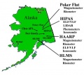
The High Latitude Monitoring Station (HLMS) is located on the outskirts of Elmendorf Air Force Base near Anchorage, Alaska. HLMS was established in 1950 by the Department of Commerce; today, it is operated by the Geophysical Institute, with one technician on the site. HLMS instruments are connected to the Geophysical Institute by leased data lines.
The primary mission of HLMS has been to monitor the earth's ionospheric environment, and to collect and reduce raw geophysical data (including seismological information) for analysis and archiving at the Geophysical Institute and other organizations nationwide.
HLMS supports the following instrumentation for ionospheric research:
- VHF auroral radar, which monitors reflections from ionospheric structures in the E-region between Poker Flat and Kaktovik.
- Magnetometer and riometer, providing information about geomagnetic and solar flare effects as part of the Remote Geophysical Operational Network (RGON), archived at the Space Environment Center in Boulder, Colorado.
- Total Electron Content (TEC) measuring equipment which monitors the density of plasma in the ionosphere overhead.
Galleria immagini
Collegamenti esterni
http://www2.gi.alaska.edu/dac2/pfrr/hlms.htm


